Powered by .id (informed decisions) for Queanbeyan-Palerang Regional Council
.id community is an evidence base for over 250 local government areas in Australia and New Zealand, helping you make informed decisions.
LEARN MORE ABOUT .idThe Queanbeyan-Palerang Regional Council local government area is located in the southern tablelands about 15 kilometres southeast of Canberra and 250 kilometres south west of Sydney. It is predominantly a rural area, with growing residential areas to the south of Queanbeyan and several towns in the Palerang area, the main being Bungendore, Braidwood and Captains Flat.
Queanbeyan has a rich history having been gazetted as a town in 1838 and serving the surrounding pastoral areas. Palerang was originally known as the Eastern Capital City Regional Council before the 2004 proclamation which created Palerang Council via several amalgamations. In 2016, together with Queanbeyan City, the Palerang Council was amalgamated to create the new Queanbeyan-Palerang Regional Council. Population growth was slow until the development of Canberra as the nation's capital, most notably after the Second World War. It was also a service centre for the major hydraulic schemes in the area, such as the Snowy Mountains Hydroelectric Scheme and more recently the Googong Dam. Around two thirds of the Palerang population was concentrated in Bungendore and the rural residential areas adjacent to the Australian Capital Territory border, with many residents commuting daily to Canberra or Queanbeyan. Cattle grazing is the primary agricultural pursuit in the former area, with more recent development of niche rural industries such as vineyards, olive groves and alpaca breeding. About one quarter of the former Palerang Council area is managed for conservation, with significant areas of national park. Queanbeyan gained a large number of overseas born as the City acted as a magnet for people leaving these projects in the sixties and seventies. In recent decades, growth in population in the City has tended to fluctuate depending on employment changes in the Commonwealth Public Sector, as well as the amount of residential land available for development in Canberra. Population growth was especially strong in the early 1980s and late 1990s, though levels have moderated in the last five years. In 1991, the population of the QPRC was just over 34,000 persons, rising to just under 58,000 at 2016.
Despite its gazettal as a separate town and location in a different State, Queanbeyan is essentially an extension of the Canberra urban area. Parts of Palerang, especially Bungendore are still well within comfortable driving distance of Canberra and are areas with moderate levels of demand, population growth and residential building activity. As a result population growth and change is heavily influenced by what is happening socially and economically in its larger neighbour. This includes the supply of residential land and employment opportunities in the Commonwealth public sector. Traditionally, Canberra has been the major source of new residents in Queanbeyan-Palerang, with around 700 more residents moving from the ACT to QPRC than vice versa. Queanbeyan-Palerang also attracts large numbers of new residents from Sydney and overseas. The City loses population to South East Queensland and other parts of southern NSW.
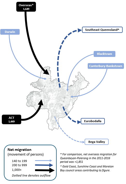
Note: The migration flows depicted above are historical and do not represent future or forecast migration flows or subsequent council boundary changes. The arrows represent migration flows to the area as a whole and do not indicate an origin or destination for any specific localities within the area. Overseas flow shows overseas arrivals based on answers to the census question "where did the person usually live 5-years ago" and .id estimates of international out-migration.
*Please note, the 2021 Census was undertaken during the COVID-19 pandemic, at a time where border restrictions had largely halted overseas in-migration for the 15 months prior. 2016-2021 net overseas migration levels reflect this and therefore should not necessarily be considered indicative of longer-term trends.
With the progressive residential development of the Queanbeyan-Palerang Region over a century and a half, the diverse nature of housing, the availability of land for development and the broad range of land uses, areas have developed different roles within the housing market. This means that population outcomes differ significantly across the City. The small areas of Queanbeyan, Queanbeyan East and Crestwood attract a large number of persons in their late teens and early twenties, which is a reflection on the large amount of affordable rental accommodation and being close to the services in central Queanbeyan, but more importantly- Canberra. Other parts of the Queanbeyan section of the region have limited residential development opportunities and their role and function will evolve over time as households mature. This process will be particularly noticeable in Jerrabomberra, which recorded its major growth phase in the 1990s and 2000s. As the supply of new residential land is largely exhausted in the existing areas, any population growth and change will come from existing households as they mature over time. However, Queanbeyan-Palerang’s growth hot spots will shift southwards as new residential opportunities in Googong and South Tralee are realised. It is assumed that these new areas will be attractive to young families seeking home owning opportunities. Other areas in the ex-Palerang side of the region, such as Bungendore will experience a gain of young families with children and a slight loss of established families who may migrate elsewhere to purchase their second home.
There are differences in the supply of residential development opportunities across the Queanbeyan-Palerang region which will also influence population growth and change over the next twenty or so years. Significant new supply has been identified in Googong (from 2014) and South Tralee (from 2020), and these will be the focus of growth in the region to 2041, and beyond. There are also opportunities for more medium and high density housing growth in established suburbs such as Crestwood, Queanbeyan and Queanbeyan East, continuing the trends of the last decade or so. On the other hand, there are limited opportunities for further residential growth in Jerrabomberra and Queanbeyan West. As a result, the population in these areas is forecast to decline over time, particularly in Jerrabomberra as the young families who moved there in the 1990s are now older, and the children leaving home to form their own households elsewhere. Overall however, the Queanbeyan-Palerang region is assumed to record moderate to strong population growth over the forecast period, to reach a population of just over 88,000 at 2041.
DISCLAIMER: While all due care has been taken to ensure that the content of this website is accurate and current, there may be errors or omissions in it and no legal responsibility is accepted for the information and opinions in this website.
Please view our Privacy Policy, Terms of use and Legal notices.
ABS Data and the copyright in the ABS Data remains the property of the Australian Bureau of Statistics. The copyright in the way .id has modified, transformed or reconfigured the ABS Data as published on this website remains the property of .id. ABS Data can be accessed from the Australian Bureau of Statistics at www.abs.gov.au. ABS data can be used under license - terms published on ABS website. intermediary.management@abs.gov.au if you have any queries or wish to distribute any ABS data.