Powered by .id (informed decisions) for Manningham City Council
.id community is an evidence base for over 250 local government areas in Australia and New Zealand, helping you make informed decisions.
LEARN MORE ABOUT .idManningham City Council is located in Melbourne’s north-eastern suburbs, commencing with its western boundary in Bulleen, 10 kilometres from the Melbourne CBD and extending to Wonga Park at its eastern extremity, 32 kilometres from the CBD.
The City encompasses a total land area of 114 square kilometres, including a substantial 17% green open spaces. The non-urban areas include a large tract of the Green Wedge, and are used mainly for rural residential living, conservation and small scale agriculture. The City includes the suburbs of Bulleen, Doncaster, Doncaster East, Donvale, Nunawading (part), Park Orchards, Ringwood North (part), Templestowe, Templestowe Lower, Warrandyte, Warrandyte South and Wonga Park (part). The City’s main centre is located at Doncaster Hill, but it also features a range of smaller shopping centres, namely The Pines, Templestowe Village, Bulleen Plaza, Macedon Square, Tunstall Square, Goldfields Plaza, Jackson Square and Devon Plaza.
The main development phase in the City of Manningham dates from the 1950s onward. Development spread into the City from the west and the south and around older villages such as Templestowe, Doncaster and Warrandyte. As car ownership increased and roads improved in the 1960s and 1970s, development spread across the City, with more areas being converted to residential and rural residential.
In recent years, the population has stabilised and begun to increase again as a result of higher levels of residential development. During the mid to late 1990s, surplus government land from utilities and former school sites provided more development potential and a number of larger remnant greenfield parcels were developed, notably in Sheehans Road, Bulleen. There was also an acceleration in the amount of redevelopment with unit and townhouse development more common in many areas of the City, notably Doncaster and Doncaster East.
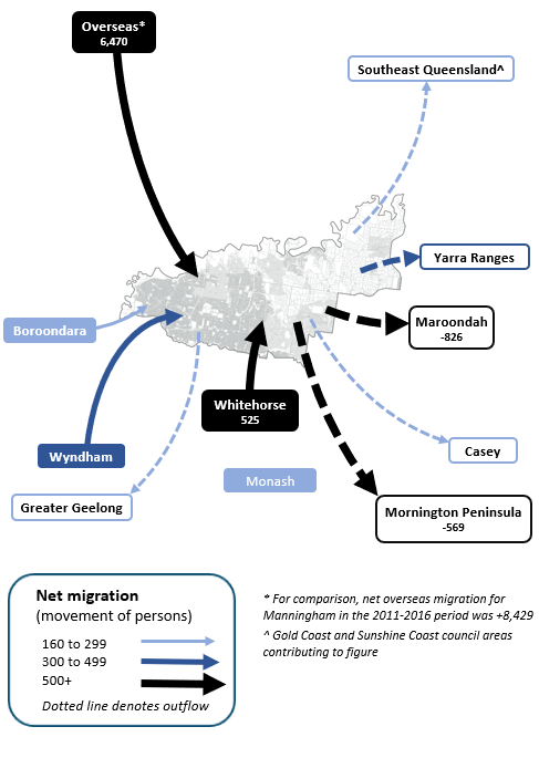
Note: The migration flows depicted above are historical and do not represent future or forecast migration flows or subsequent council boundary changes. The arrows represent migration flows to the area as a whole and do not indicate an origin or destination for any specific localities within the area. Overseas flow shows overseas arrivals based on answers to the census question "where did the person usually live 5-years ago" and .id estimates of international out-migration.
*Please note, the 2021 Census was undertaken during the COVID-19 pandemic, at a time where border restrictions had largely halted overseas in-migration for the 15 months prior. 2016-2021 net overseas migration levels reflect this and therefore should not necessarily be considered indicative of longer-term trends.
Within the City of Manningham, areas have developed and will continue to evolve different roles within the housing market. Variations occur due to when areas were settled, the range of land uses in the area, developer interest and the varying planning policies in play. Bulleen and Doncaster Hill tends to gain people in their late teens and twenties due to a combination of factors. These include affordability and relative proximity to the City (Bulleen) and access to services and available rental stock (Doncaster Hill). Areas such as Doncaster East, Donvale, Park Orchards, Templestowe, Templestowe lower, Warrandyte-Warrandyte South and Wonga Park attract established and mature families, due to the type of housing stock available. Doncaster Balance attracts a combination of young adults and mature families.
DISCLAIMER: While all due care has been taken to ensure that the content of this website is accurate and current, there may be errors or omissions in it and no legal responsibility is accepted for the information and opinions in this website.
Please view our Privacy Policy, Terms of use and Legal notices.
ABS Data and the copyright in the ABS Data remains the property of the Australian Bureau of Statistics. The copyright in the way .id has modified, transformed or reconfigured the ABS Data as published on this website remains the property of .id. ABS Data can be accessed from the Australian Bureau of Statistics at www.abs.gov.au. ABS data can be used under license - terms published on ABS website. intermediary.management@abs.gov.au if you have any queries or wish to distribute any ABS data.