Powered by .id (informed decisions) for Wellington Shire
.id community is an evidence base for over 250 local government areas in Australia and New Zealand, helping you make informed decisions.
LEARN MORE ABOUT .idWellington Shire is in eastern Victoria’s Gippsland region and is the State’s third largest LGA. The LGA encompasses a diverse range of land uses and landforms. The northern parts are remote and densely forested, rising from the Latrobe Valley into the mountains of the Victorian Alps, some of the highest peaks in Australia, with some parts used for timber production. The main population centres are generally located in the central fertile flood plains surrounded by land that is mainly used for grazing and agriculture. To the south, there are small coastal settlements, with both long term and short-term residents. These diverse natural features are fundamental in shaping the development of the Shire.
The attraction of the region’s natural amenity acts as one of the main drivers for population growth, particularly for sea changers. There is a dual housing market in operation, consisting both of retirees and families. The Shire gains population through migration from outer Eastern & South Eastern Melbourne, yet loses locally to neighbouring LGAs, such as La Trobe, East Gippsland, and Baw Baw. In common with most parts of regional Australia, Wellington loses young adults to Melbourne for education, employment and lifestyle reasons.
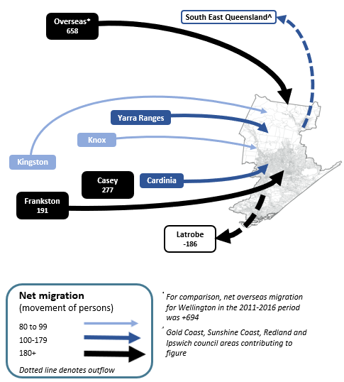
Note: The migration flows depicted above are historical and do not represent future or forecast migration flows or subsequent council boundary changes. The arrows represent migration flows to the area as a whole and do not indicate an origin or destination for any specific localities within the area. Overseas flow shows overseas arrivals based on answers to the census question "where did the person usually live 5-years ago" and .id estimates of international out-migration.
*Please note, the 2021 Census was undertaken during the COVID-19 pandemic, at a time where border restrictions had largely halted overseas in-migration for the 15 months prior. 2016-2021 net overseas migration levels reflect this and therefore should not necessarily be considered indicative of longer-term trends.
The largest town Sale, has a significant regional centre function with a variety of services (high schools, TAFE, hospitals, local and state government) serving the entire Wellington area. The East Sale RAAF base is a major feature of the area. It is a major training centre for the Air Force. Resultant defence industries and health care are major employers. Major agricultural centres of Maffra (second largest town in Wellington, with about 6,000 people), Stratford, Heyfield and Rosedale are situated in the Central Gippsland plains, along the Avon and Latrobe Rivers, and are mainly service centres for the surrounding rich farmland. Wellington’s natural amenity encourages tourism to the region. The Ninety Mile Beach stretches from Port Albert to Lakes Entrance (in East Gippsland Shire), and the towns along this stretch are smaller and characterised by a high rate of holiday homes which are generally unoccupied on Census night but fill up over summer. These towns include Loch Sport, Golden Beach and Seaspray.
Future growth in Wellington is likely to occur in the main towns, particularly the northern part of Sale, where there is considerable residential supply and existing services. Rural residential development around Maffra and Longford, is another important source of future supply for those seeking rural lifestyle opportunities within easy access of a major regional centre. This is anticipated to increase over the course of the forecast. Minimal growth is forecast for the more remote rural areas, continuing the trend of stable population change. Overall, the population is forecast to grow from around 43,532 in 2021 to 57,191 in 2041.
DISCLAIMER: While all due care has been taken to ensure that the content of this website is accurate and current, there may be errors or omissions in it and no legal responsibility is accepted for the information and opinions in this website.
Please view our Privacy Policy, Terms of use and Legal notices.
ABS Data and the copyright in the ABS Data remains the property of the Australian Bureau of Statistics. The copyright in the way .id has modified, transformed or reconfigured the ABS Data as published on this website remains the property of .id. ABS Data can be accessed from the Australian Bureau of Statistics at www.abs.gov.au. ABS data can be used under license - terms published on ABS website. intermediary.management@abs.gov.au if you have any queries or wish to distribute any ABS data.