Powered by .id (informed decisions) for City of Belmont
.id community is an evidence base for over 250 local government areas in Australia and New Zealand, helping you make informed decisions.
LEARN MORE ABOUT .idThe City of Belmont is a Western Australian local government area, located in the inner eastern suburbs of Greater Perth. It is situated about 8 kilometers east of Perth’s CBD. The City of Belmont is bounded by the City of Bayswater and the Town of Bassendean in the north, the City of Swan in the east, the City of Kalamunda and the City of Canning in the south, and the Town of Victoria Park in the west.
The City of Belmont is named after Belmont Farm, one of the first farms to be established in the Swan River Colony. Long before settlers arrived, however, Noongar people had names for the places they owned and used. For example, the site of Ascot Racecourse was formerly known as Ngattaba. In the late 1890s the gold rush brought many people to the area and housing demand increased vastly. Brickworks used the clay by the river. Poultry farms, dairies and piggeries also sprung up, along with Chinese market gardens. The effects of the gold rush were vast. Perth quickly became a city, and old wooden buildings were torn down, replaced by new brick ones. The increases in population led to a demand for housing. In the 1890s, speculators began buying up Belmont land for subdivision. Ascot was an early and successful subdivision in the City. Designed as a "garden suburb", the river end of the suburb was advertised to middle-class buyers who were looking for a brick bungalow on a quarter-acre block. Redcliffe Farm developed from 1895 however subdivisions in South Perth and Victoria Park proved more popular than those further out in Belmont.
Eventually, settlement began to extend further down Belmont Avenue into Kewdale and Cloverdale. The new residents were pig farmers attracted by low rates and cheap land. By the end of the 1890s, Chinese market gardeners were also prominent in the Belmont area. Until the late 1890s, there was practically no planning control in Belmont. Agricultural and timber businesses were unregulated, and the increasing population needed roads.
In recent years, the migration patterns in the City of Belmont have been dictated by its place in metropolitan Perth and by its role and function. Largest net migration gains nowadays are from overseas although not all of those new residents necessarily come to the City of Belmont directly from overseas, some may live elsewhere first before settling here. Internally, the City of Belmont gains most residents from Victoria Park, South Perth, Canning, Bayswater and the City of Perth itself. Interestingly, there is also a net gain of residents to the city from Kalgoorlie/Boulder, a reflection of the wide influence that the mining industry has in Western Australia. Net losses of residents are to the LGAs of Swan, Kalamunda, Gosnells, Armadale, Rockingham, Wanneroo and several other growth areas which have a steady supply of housing to meet the needs of local residents, usually young family-forming couples, who are looking to establish themselves elsewhere and find more preferred housing opportunity.
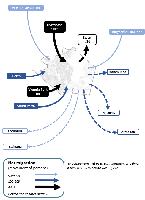
Note: The migration flows depicted above are historical and do not represent future or forecast migration flows or subsequent council boundary changes. The arrows represent migration flows to the area as a whole and do not indicate an origin or destination for any specific localities within the area. Overseas flow shows overseas arrivals based on answers to the census question "where did the person usually live 5-years ago" and .id estimates of international out-migration.
*Please note, the 2021 Census was undertaken during the COVID-19 pandemic, at a time where border restrictions had largely halted overseas in-migration for the 15 months prior. 2016-2021 net overseas migration levels reflect this and therefore should not necessarily be considered indicative of longer-term trends.
Within the City, there are some differences in terms of role and function. Ascot plays a more diverse housing market role with modest gain in several age groups, namely tertiary students, mature families and empty nesters. Belmont and Rivervale have a role and function dominated by gains of university students and the young workforce. This net migration profile is similar to what the Redcliffe-Perth Airport small area experiences. Cloverdale mirrors the City of Belmont’s role and function with a gain of young adults and a loss of families who move away in search of preferred housing elsewhere. On the other hand, the suburb of Kewdale is forecasted to gain families aged 25-34 year olds with 0-9 year old children.
In the short term, many high density developments have developed mainly in Rivervale with some more high density developments identified in Rivervale but also Belmont and Ascot. Large scale developments such as The Springs have been developing in Rivervale for several years now and are expected to continue until completion in the mid 2020s. From the later part of the 2020s, the development of the "Development Area 6 Vision" (DA6 Vision) area will contribute much dwelling supply to the Redcliffe-Perth Airport area in the form of medium/high density dwellings and along with business and commercial development of the Belmont Business Park in the same period, the City of Belmont may begin to experience retention of some of those residents who previously left the area in search of more readily available and family-preferred housing opportunity elsewhere.
DISCLAIMER: While all due care has been taken to ensure that the content of this website is accurate and current, there may be errors or omissions in it and no legal responsibility is accepted for the information and opinions in this website.
Please view our Privacy Policy, Terms of use and Legal notices.
ABS Data and the copyright in the ABS Data remains the property of the Australian Bureau of Statistics. The copyright in the way .id has modified, transformed or reconfigured the ABS Data as published on this website remains the property of .id. ABS Data can be accessed from the Australian Bureau of Statistics at www.abs.gov.au. ABS data can be used under license - terms published on ABS website. intermediary.management@abs.gov.au if you have any queries or wish to distribute any ABS data.