Powered by .id (informed decisions) for Upper Lachlan Shire
.id community is an evidence base for over 250 local government areas in Australia and New Zealand, helping you make informed decisions.
LEARN MORE ABOUT .idUpper Lachlan Shire is located in the Southern Tablelands of New South Wales, about 240 kilometres south-west of the Sydney CBD and 140 kilometres north of Canberra. It is primarily a rural area with towns at Crookwell, Gunning and Taralga, as well as a number of smaller centres. The region has a high level of natural amenity due to its rural landscapes and national parks. The Hume Highway and the Sydney-Melbourne railway run through the southern part of the Shire,
European settlement of the area dates from the 1820s, with land used mainly for grazing and crop growing, and later some potato growing. Population was minimal until the 1840s. Growth took place from the 1850s into the late 1800s when several townships and villages were established, spurred by gold mining and the opening of the railway line from Sydney. Expansion resumed during the post-war years, with population decline from the 1960s. The population of the Shire fluctuated slightly between 1991 and 2011, and has slowly increased to about 8,500 by 2021.
Upper Lachlan Shire has a migration profile that is typical of regional Australia. There is significant out-migration of young adults (18-24 years), primarily for education and employment purposes. Many of these young adults would be heading for Canberra due to its proximity. Upper Lachlan Shire attracts younger families, typically with children aged 0-9 years, and a small number of older adults and retirees. Overall, Upper Lachlan Shire loses population to the ACT and to neighbouring Goulburn - Mulwaree Council, but gains population from other parts of southern NSW and interestingly - South East Queensland.
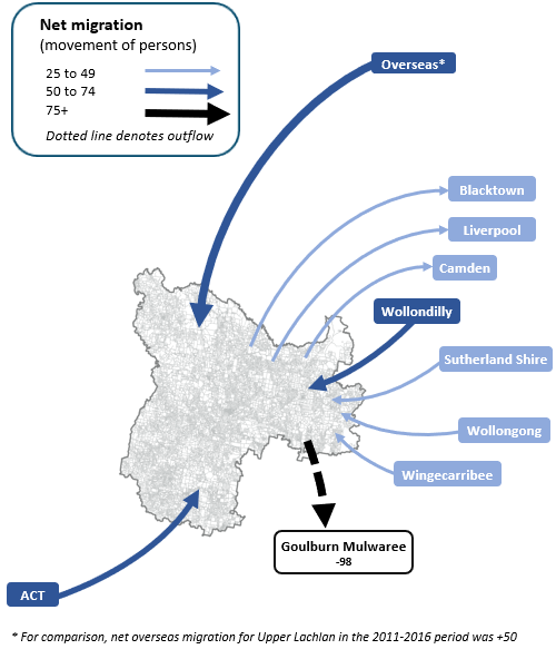
Note: The migration flows depicted above are historical and do not represent future or forecast migration flows or subsequent council boundary changes. The arrows represent migration flows to the area as a whole and do not indicate an origin or destination for any specific localities within the area. Overseas flow shows overseas arrivals based on answers to the census question "where did the person usually live 5-years ago" and .id estimates of international out-migration.
*Please note, the 2021 Census was undertaken during the COVID-19 pandemic, at a time where border restrictions had largely halted overseas in-migration for the 15 months prior. 2016-2021 net overseas migration levels reflect this and therefore should not necessarily be considered indicative of longer-term trends.
Despite the rural settlement pattern and small population size there are subtle differences in the housing role and function between the small areas. All areas attract younger families, but this role is more apparent in Gunning - Dalton and District. On the other hand, Taralga - Rural Upper Lachlan has a dual housing market focussed on retirees in addition to younger families.
Expansion of existing towns and villages in Upper Lachlan Shire is dependent on the supply of residential land but more importantly, the demand for future development. Gunning - Dalton and District benefit from closer proximity to Canberra and the Hume Highway, whereas Taralga - Upper Rural Lachlan has a high amenity factor and may benefit from its proximity to the Southern Tablelands towns. Residential supply has been identified in all small areas and it is assumed that each area will record modest growth into the future. Overall, around 250 dwellings are assumed in Upper Lachlan Shire in the forecast period, resulting in little population change to 2036.
DISCLAIMER: While all due care has been taken to ensure that the content of this website is accurate and current, there may be errors or omissions in it and no legal responsibility is accepted for the information and opinions in this website.
Please view our Privacy Policy, Terms of use and Legal notices.
ABS Data and the copyright in the ABS Data remains the property of the Australian Bureau of Statistics. The copyright in the way .id has modified, transformed or reconfigured the ABS Data as published on this website remains the property of .id. ABS Data can be accessed from the Australian Bureau of Statistics at www.abs.gov.au. ABS data can be used under license - terms published on ABS website. intermediary.management@abs.gov.au if you have any queries or wish to distribute any ABS data.