Powered by .id (informed decisions) for Shire of Serpentine Jarrahdale
.id community is an evidence base for over 250 local government areas in Australia and New Zealand, helping you make informed decisions.
LEARN MORE ABOUT .idThe Shire of Serpentine Jarrahdale is a predominantly rural Local Government Area, with the largest townships at Byford and Mundijong about 35 and 45 kilometres south of Perth respectively. The eastern areas of the Shire are dominated by conservation, timber and water catchment uses, with major water storages for Perth such as the Wungong Reservoir (part) and the Serpentine Dam located in the Shire. The central spine of the Shire of Serpentine Jarrahdale features many of the urban centres and the main transport corridor. Towns such as Byford, Mundijong and Serpentine and linked by the South Western Highway and the Bunbury Railway. The western end of the Shire remains predominantly rural, with a relatively small population. However, the outward growth of Metropolitan Perth towards the Shire in recent years has already and will continue to change these land use dynamics, with extra pressure for urban and rural residential expansion at the northern end of the Shire.
The Shire currently features a relatively small residential population, with the majority of residents located in the towns of Byford, Mundijong, Serpentine and Jarrahdale, as well as in rural residential areas in Oakford and Darling Downs. The rural residential areas around Byford, Oakford and Darling Downs feature a large share of equine properties, with significant training facilities. The economic base of the Shire of Serpentine Jarrahdale is still strongly oriented towards primary industries, although a large share (more than half) of residents work outside the Shire. Other important industries include construction (driven by housing growth in the region) and other services, such as retail trade, education and health.
The population of Serpentine Jarrahdale has been relatively small until recent decades, with the expansion of Perth southward. The population of the Shire was just over 5,000 in 1981, growing to more than 8,000 by 1991 and up to 18,500 by 2011. Most of this growth was driven by small rural residential development and incremental developments at the fringe of the population centres. In recent years, residential development has increased dramatically, with a much larger share of 'conventional' fringe residential development. As development rates in the City of Gosnells slow, more residential development is likely to spill into the Shire of Serpentine Jarrahdale (as well as the City of Armadale).
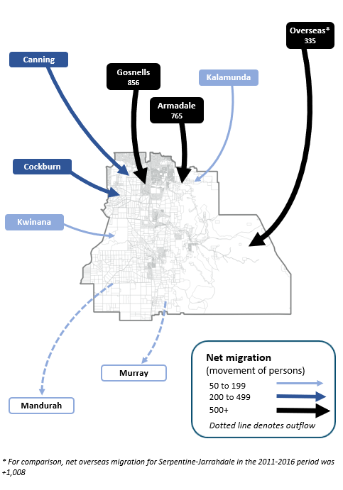
Note: The migration flows depicted above are historical and do not represent future or forecast migration flows or subsequent council boundary changes. The arrows represent migration flows to the area as a whole and do not indicate an origin or destination for any specific localities within the area. Overseas flow shows overseas arrivals based on answers to the census question "where did the person usually live 5-years ago" and .id estimates of international out-migration.
*Please note, the 2021 Census was undertaken during the COVID-19 pandemic, at a time where border restrictions had largely halted overseas in-migration for the 15 months prior. 2016-2021 net overseas migration levels reflect this and therefore should not necessarily be considered indicative of longer-term trends.
The primary housing market role that the Shire has played over the last two decades has been to provide rural-based lifestyles within commuting distance of employment in Perth. Recent developments are likely to provide relatively affordable housing for young and established families from southern Perth. This role is expected to continue and expand as the stocks of residential land in Gosnells are depleted and as housing costs in Perth remain high. The majority of people moving to the Shire of Serpentine Jarrahdale are expected to come from established areas in southern-eastern Perth
Within the Shire of Serpentine Jarrahdale, areas have developed and will continue to evolve different roles within the housing market. Variations occur due to environmental and aesthetic differences, the type and quality of residential and rural residential development being undertaken, the range of land uses in the area and accessibility to employment and services. As the largest main growth area of the Shire, Byford attracts people in all age groups, especially young and established families. Other areas such as Cardup, Oldbury, Jarrahdale and Serpentine attract families as well as some empty-nesters and young retirees. Oakford and Darling Downs tends to attract a greater share of mature families, while Mundijong is likely to attract much larger numbers of persons when greater levels of residential development occur over the following decade.
There are also significant differences in the supply of residential land within the Shire which will also have a major influence in structuring different population and household futures over the next five to twenty years. In the short to medium term, large greenfield stocks are available in Byford, as well as smaller rural residential opportunities across the Shire of Serpentine Jarrahdale. In the longer term, these areas are likely to be supplemented by a range of new greenfield areas primarily in Mundijong and surrounds.
DISCLAIMER: While all due care has been taken to ensure that the content of this website is accurate and current, there may be errors or omissions in it and no legal responsibility is accepted for the information and opinions in this website.
Please view our Privacy Policy, Terms of use and Legal notices.
ABS Data and the copyright in the ABS Data remains the property of the Australian Bureau of Statistics. The copyright in the way .id has modified, transformed or reconfigured the ABS Data as published on this website remains the property of .id. ABS Data can be accessed from the Australian Bureau of Statistics at www.abs.gov.au. ABS data can be used under license - terms published on ABS website. intermediary.management@abs.gov.au if you have any queries or wish to distribute any ABS data.