Powered by .id (informed decisions) for Rural City of Murray Bridge
.id community is an evidence base for over 250 local government areas in Australia and New Zealand, helping you make informed decisions.
LEARN MORE ABOUT .idThe Rural City of Murray Bridge is located in the Murraylands Region of South Australia, about 76 kilometres south-east of the Adelaide CBD. The area is rural in nature, and its settlement pattern is focused on the Murray Bridge township, which is situated on the Murray River and the Princess Highway, the major transport link between Adelaide and Melbourne. The remainder of the council area consists of rural areas including the smaller settlements of Avoca Dell, Callington, Mypolonga, Sunnyside, Wellington, White Sands and Woodspoint.
The Rural City of Murray Bridge acknowledges that the Ngarrindjeri people were the first peoples of this country.
Captain Charles Sturt was the first European in the area and, in 1930, set out to row down the Murray River to solve the mystery of why so many rivers flowed westward from the Great Dividing Range. From this time, it was thought that the Murray River could be used for transport. European settlement dates from the mid-1850’s, with land used mainly for grazing and crop farming.
Murray Bridge was established when a road bridge over the river was completed in 1879. It was followed in 1886 by the Adelaide-Melbourne railway line which guaranteed the city’s importance as a vital link across the river. Subsequent wharf facilities created a busy centre for river trade, resulting in the establishment of housing and supporting industry. The original township was laid out in 1883 and was called Mobilong, with the land sold in Adelaide in 1884. Later it was called Edwards Crossing, but became Murray Bridge when another railway bridge was constructed across the river in 1924. Development was concentrated along the east-west transit route formed by Adelaide Road and its western connection (Bridge Street) to the bridge. The planning of Murray Bridge was generally determined by geographical and transport infrastructural constraints, including the railway line to the north, the River Murray to the east and the South Eastern Freeway to the south.
South Australia’s third largest provincial city, the population of the Rural City of Murray Bridge has increased from around 17,000 in 2001 to almost 22,500 in 2021. Access to services, good transport links to Adelaide and relatively lower-cost housing have acted as significant drivers for growth in recent years.
A significant source of in-migration to the Rural City of Murray Bridge is from overseas. Primary sources of intrastate in-migration were from the adjacent councils of the Coorong and Tatiara. Miration inflows come from other South Australian regional centres (Coorong, Mid Murray, Alexandrina). Migration outflows were largely to Adelaide Metropolitan areas which offer greater opportunities for employment and education. Established families (children aged 5-14 years, parents 34-44 years) formed the main source of in-migration attracted to relatively lower-cost housing and services in a regional environment with transport links to Adelaide.
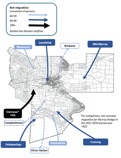
Note: The migration flows depicted above are historical and do not represent future or forecast migration flows or subsequent council boundary changes. The arrows represent migration flows to the area as a whole and do not indicate an origin or destination for any specific localities within the area. Overseas flow shows overseas arrivals based on answers to the census question "where did the person usually live 5-years ago" and .id estimates of international out-migration.
*Please note, the 2021 Census was undertaken during the COVID-19 pandemic, at a time where border restrictions had largely halted overseas in-migration for the 15 months prior. 2016-2021 net overseas migration levels reflect this and therefore should not necessarily be considered indicative of longer-term trends.
There are significant opportunities for new residential development in established areas of Murray Bridge along Christian Road, Newbridge development (old racecourse) and River Central Land Development. Avoca Dell Estate (Stage 2 & 3) and Loddon Road in the East Side offer "rural living" options with larger allotments. Longer term residential land supply can be met through recently rezoned residential/rural/urban growth areas in the southern (e.g. Gifford Hill) and eastern outskirts of Murray Bridge township.
DISCLAIMER: While all due care has been taken to ensure that the content of this website is accurate and current, there may be errors or omissions in it and no legal responsibility is accepted for the information and opinions in this website.
Please view our Privacy Policy, Terms of use and Legal notices.
ABS Data and the copyright in the ABS Data remains the property of the Australian Bureau of Statistics. The copyright in the way .id has modified, transformed or reconfigured the ABS Data as published on this website remains the property of .id. ABS Data can be accessed from the Australian Bureau of Statistics at www.abs.gov.au. ABS data can be used under license - terms published on ABS website. intermediary.management@abs.gov.au if you have any queries or wish to distribute any ABS data.