Powered by .id (informed decisions) for Ballina Shire Council
.id community is an evidence base for over 250 local government areas in Australia and New Zealand, helping you make informed decisions.
LEARN MORE ABOUT .idBallina Shire is located on the Far North Coast of New South Wales, about 770 kilometres north of Sydney and 190 kilometres south of Brisbane. Ballina Shire is bounded by Byron Shire in the north, the Coral Sea in the east, the Richmond Valley Council area in the south, and the City of Lismore in the west.
European settlement dates from 1842, with land used mainly for timber-getting and agriculture. From the 1860s, land was used more for growing sugar cane, maize and for dairy farming.
Ballina Shire is served by the Pacific Highway, the Bruxner Highway, and Ballina Byron Gateway Airport. Major features of the Shire include North Coast TAFE (Ballina and Wollongbar Campuses), the Ballina CBD, Ballina Fair Shopping Centre, Ballina District Hospital, Ballina Racecourse, Ballina Naval & Maritime Museum, Crawford House Museum, The Macadamia Castle, Thursday Plantation, the Richmond River and various beaches and nature reserves. Ballina Shire contains a diversity of housing, ranging from homesteads in rural areas to post-war residential in areas such Ballina Island, Ballina East, Alstonville and Wollongbar.
From the 1860s, land was used more for sugar cane growing, maize growing and dairy farming. Gradual growth took place during the late 1800s. Significant development occurred from the post-war years, with the population increasing from about 8,000 in 1947 to about 9,000 in 1966. Rapid growth took place during the 1970s and 1980s. The population increased from under 11,000 in 1971 to 19,000 in 1981, and then to 30,000 in 1991. The population continued to increase from the 1990s, rising to over 39,000 in 2011, with growth slowing between 2006 and 2011. The population forecast is likely to increase to 51,000 in 2036
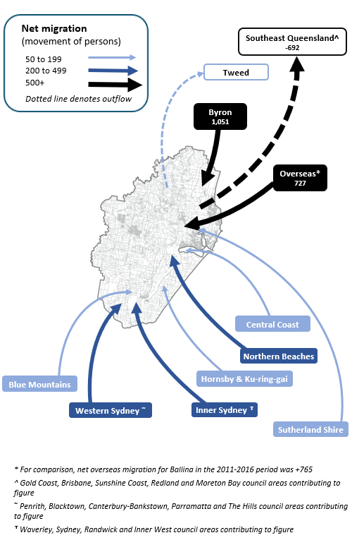
Note: The migration flows depicted above are historical and do not represent future or forecast migration flows or subsequent council boundary changes. The arrows represent migration flows to the area as a whole and do not indicate an origin or destination for any specific localities within the area. Overseas flow shows overseas arrivals based on answers to the census question "where did the person usually live 5-years ago" and .id estimates of international out-migration.
*Please note, the 2021 Census was undertaken during the COVID-19 pandemic, at a time where border restrictions had largely halted overseas in-migration for the 15 months prior. 2016-2021 net overseas migration levels reflect this and therefore should not necessarily be considered indicative of longer-term trends.
Opportunities for new dwellings are likely to be greatest in a number of strategic greenfield growth areas including Ballina North, Cumbalum, Lennox Head, Skennars Head and Wollongbar. Ballina Island is expected to experience some new infill/minor site dwellings.
DISCLAIMER: While all due care has been taken to ensure that the content of this website is accurate and current, there may be errors or omissions in it and no legal responsibility is accepted for the information and opinions in this website.
Please view our Privacy Policy, Terms of use and Legal notices.
ABS Data and the copyright in the ABS Data remains the property of the Australian Bureau of Statistics. The copyright in the way .id has modified, transformed or reconfigured the ABS Data as published on this website remains the property of .id. ABS Data can be accessed from the Australian Bureau of Statistics at www.abs.gov.au. ABS data can be used under license - terms published on ABS website. intermediary.management@abs.gov.au if you have any queries or wish to distribute any ABS data.